I knew about Newcastle’s mining history, of course, and been
warned of the potential for mine subsidence. Still, I was vague about what had
happened in Hamilton, and curious to know where the mine shafts had been, in
relation to our house.
When we finally came to live here, I noticed three things
about the landscape – it was flat, the soil was light and sandy, and there were
relatively few trees. Good for walking and cycling; not so for gardening.
I found myself wondering what the area had looked like in
the earliest days of its settlement. I was curious, too, about whether there
had been any evidence of Aboriginal occupation before mining began.
This wonderful photograph by Ralph Snowball, taken in 1897, looks back to the original mining settlements along the track that would become Beaumont Street (eventually Hamilton's main street) from the vantage point of Glebe Hill.

This wonderful photograph by Ralph Snowball, taken in 1897, looks back to the original mining settlements along the track that would become Beaumont Street (eventually Hamilton's main street) from the vantage point of Glebe Hill.

AA Company's Agricultural Field near Glebe Hill (1897)
From Norm Barney Photographic Collection, reproduced courtesy of Cultural Collections,
University of Newcastle, Australia
The best historical account I have found of the development of Hamilton is self published by Peter Murray – From Borehole to Hamilton Jubilee 1848 – 1921 (2006). It is meticulously researched, with careful documentation of primary and secondary sources. From this work I have been able to gain an appreciation of how Hamilton might have looked in its early days.
The earliest settlements, an assorted collection of mine
workings, primitive slab huts and lean-tos, a few brick houses and a brick
yard, clustered around what was known as Cameron’s Hill. Picture the
intersection of Denison Street and Beaumont Street as it is today, and move
westwards up the slope, towards St Peter’s Anglican Church and Hamilton Public
School. That seems to be where the hub of activity focused.

The first mines in the area that was to become Hamilton were
the D and E Pits. The D Pit (opened in 1849) was known as the Borehole Seam,
between what is now Denison and Veda Streets.
.jpg)
AA Company's Borehole No. 2 Pit, Hamilton
Courtesy Newcastle Region Library
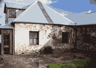
James Lindsay was first Overman or undermanager of D Pit, and was provided with a four room brick house that would have been of substantially higher standard than the housing rented to the miners, or the slab huts pictured above. The house (pictured below) is still standing on a small battleaxe block entered from 195 Denison Street, owned (and in the process of being conserved) by the Newcastle City Council. Read more here.
The E Pit was located between Everton and Dumaresq Streets. The imaginatively named A, B and C Pits were in Newcastle – coal mining had begun there in 1804. The F Pit was sunk by Frank Beaumont, the Company’s new Mine Manager. It’s obvious where Beaumont Street and Lindsay Streets got their names.
In the early days of settlement, the landscape
was mostly sandy, scrubby bushland. Vegetation was sparse and scrappy, and the
few trees were stunted. There were no properly made roads. The streets – such
as they were – were just tracks with scrub on both sides; snakes were common.
People walked where they needed to go.
The glare from the creamy white sand was blinding in the
midday sun. Beneath these extensive sand beds lay substantial reserves of
artesian water. Fed by two creeks – the tidal Styx Creek to the west and
Cottage Creek to the east – the area often flooded and became swampy after
heavy rains. Look at these floods in Gregson Park!

Flood at Gregson Park (1908)
Courtesy Newcastle Region Library
The flats were great for horse racing, and it didn’t take long for the residents to get organised. I learned from the Newcastle Jockey Club web site that the first race meeting was held in 1848 on a track cleared through bush and scrub in an area known as Wallaby Flat. Early accounts by the settlers reported that Wallaby Flat, which took in most of Hamilton, as well as part of Broadmeadow and Merewether, was good for hunting wildlife such as kangaroos.
While it is known that the Awabakal people have had a long
association with this land, there is little or no evidence of Aboriginal
occupation because of the particularly destructive effect of mining on the
landscape. Every bit of archeological evidence seems to have gone.
Yet Aboriginal people were still around. There is a record
of “heat, flies and Aboriginal
corrobories (sic) which were held in the vicinity of the race-course” [1] in the recollections of David Murray’s great grandmother
Elizabeth, who in 1857 settled in what would become Hamilton.
Three settlements grew up around the mines – Bore Hole
(houses and cottages running down Denison/Winship Street to Beaumont Street),
Pit Town (Beaumont Street to Swan Street) and Happy Flat, or Happy Valley. Memories of Dugald Dobie growing up in these early days were of a collection of 20 or 30 huts, with the only shop being Mrs Winn's, on Cameron's Hill.
In 1871, the population of Hamilton was 854 people.
In 1871, the population of Hamilton was 854 people.
It was the story of the communal wells that provided me with a vital clue as to where my home is in relation to the early settlements.
There were at least three wells used by the miners’ families. I read a poignant account of women taking their washing to a well in Steel Street, then hanging clothes on makeshift lines or tree branches nearby. A second well was in Chaucer Street.
The third well was just around the corner from where I live, at the intersection of Denison and Lawson Streets. Apparently it served the Happy Flat community, thought to be located near present day Turner Street. So, it transpires that my street was once part of Happy Flat!
I know that the Newcastle Region Library has a large collection
of historical maps and plans, and one day I will investigate these. Today, it
is enough to know that where I live was one of the earliest mining settlements,
Happy Flat, and most likely, we live above a honeycomb of mine shafts.
A few enterprising miners were able to make good and purchase land from the AA Company to build their own homes. James Webster purchased a corner block on what was to become Webster Street in 1858, where he opened a general store and post office. These early miners gave their names to several of the streets near where I live, including one which runs parallel - mine .
This blog is my journey to discover my suburb's past. I'm not a historian, just an ordinary person doing some research.
Can you tell me more?
No comments:
Post a Comment